
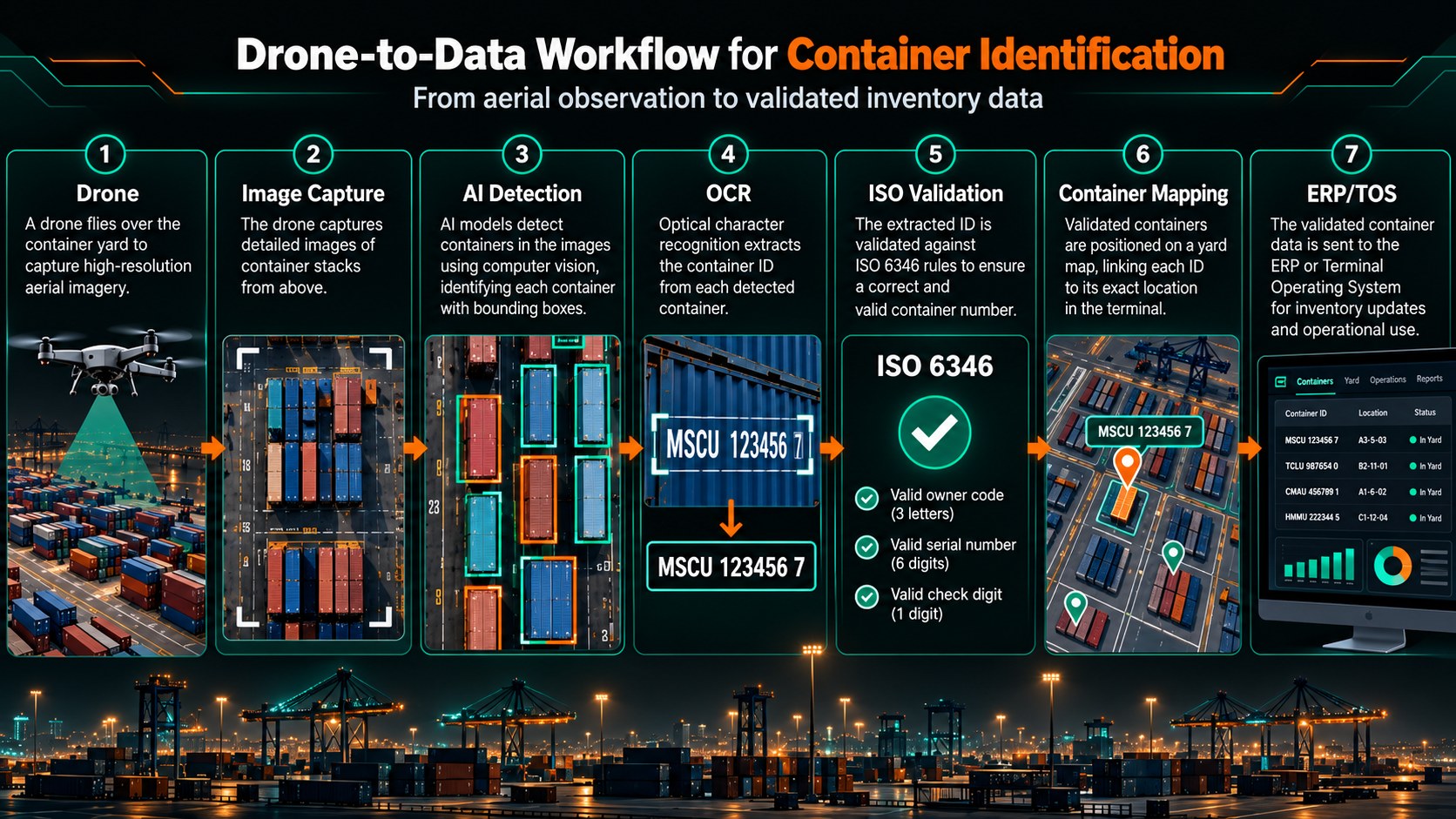
How autonomous aerial systems, computer vision and intelligent data processing could transform container identification, localisation and inventory management in complex port environments.
The Visibility Challenge in Modern Container Terminals
Modern container terminals are among the most complex logistics environments in the world.
Every day, thousands of containers are moved, stacked, repositioned and transferred between ships, trucks, trains and storage areas. Maintaining accurate information about their identity and physical location is essential to efficient terminal operations.
Yet even with sophisticated Terminal Operating Systems (TOS), automated handling equipment and digital inventory management platforms, a fundamental challenge remains: the information recorded in a system does not always perfectly reflect the physical reality on the ground.
A container may have been relocated without its position being correctly updated. An identification number may have been entered incorrectly. Operational changes may create discrepancies between the expected and actual location of an asset.
When this happens, locating a particular container can become a time-consuming and resource-intensive task.
For large terminals, where containers may be stacked several levels high and distributed across extensive storage areas, physically verifying their positions is not always straightforward.
This raises an important question:
Can autonomous drones and artificial intelligence help bridge the gap between digital inventory records and the physical reality of container terminals?
When Digital Records and Physical Reality No Longer Match
Container terminals depend on accurate, continuously updated information.
Each container movement generates operational data that should ultimately be reflected in the terminal's management systems.
However, even highly digitalised operations can experience discrepancies.
A container recorded in one position may have been moved to another. A damaged or incorrectly captured identification number may complicate tracking. Temporary operational constraints may also affect the accuracy or timeliness of location updates.
The problem is not necessarily the absence of data. It is the difficulty of independently verifying that this data remains accurate.
Traditional verification methods frequently involve ground personnel, vehicle-based inspections or fixed camera installations.
These approaches can be effective, but they also present limitations.
Ground-level inspections may require personnel to navigate large operational areas. Fixed cameras cannot always provide visibility across every stack or aisle. Narrow passages, container height and constant equipment movements can create significant visual obstructions.
The result is a familiar operational challenge: knowing where a container should be located is not always the same as knowing where it actually is.
Addressing this discrepancy requires a reliable way to observe, identify and associate physical containers with their corresponding digital records.
From Aerial Images to Container Identification
Drones introduce a different perspective.
Rather than relying exclusively on fixed observation points or ground-based inspections, unmanned aerial systems can capture visual information from multiple positions and viewing angles.
Depending on the terminal's configuration, this can include elevated views of container stacks, inspections along accessible corridors and targeted observations of specific storage areas.
The objective is not simply to produce aerial photographs.
It is to transform visual observations into structured operational information.
This is where computer vision and Optical Character Recognition (OCR) become particularly relevant.
Shipping containers use internationally standardised identification markings under ISO 6346.
A typical identification number contains four letters, six serial-number digits and one check digit. This structure allows software to perform basic validation of recognised identifiers.
By combining drone imagery with computer vision and OCR algorithms, it becomes possible to develop a workflow that:
- Detects containers within captured images or video sequences.
- Identifies visible container markings.
- Extracts identification numbers using OCR.
- Validates candidate numbers against the ISO 6346 structure and check-digit rules.
- Associates confirmed observations with an estimated physical location.
- Compares identified containers with existing inventory records.
In principle, such a system could support the search for misplaced containers, inventory verification and the identification of discrepancies between physical observations and digital records.
However, the distinction between what is technically possible and what is operationally reliable is critical.
Why Container Identification Is More Complex Than It Appears
At first glance, reading a container number may seem like a relatively simple computer vision task.
In practice, container terminals present several conditions that make automated identification considerably more difficult.
1. Limited visibility between stacked containers
Containers are frequently arranged in dense rows, with narrow aisles and multiple stacking levels.
A drone observing a container from above may not have a direct view of its identification markings.
Conversely, operating between closely spaced rows can introduce navigation, positioning and collision-avoidance challenges.
A reliable solution must therefore consider the physical geometry of the terminal and determine which observation angles provide useful information.
2. Environmental conditions
Ports are demanding operational environments.
Wind, rain, sea spray, variable lighting and reflective surfaces can influence both drone operations and image quality.
Container markings may also be partially obscured by corrosion, dirt, structural elements or damage.
These conditions directly affect the reliability of automated text recognition.
3. Image quality and perspective
Successful OCR depends on more than the nominal resolution of a camera.
Viewing distance, camera angle, motion blur, stabilisation, lens characteristics and the number of pixels covering individual characters can all influence recognition performance.
A visually clear aerial image does not necessarily contain sufficient information for reliable container identification.
4. Recognition errors and uncertainty
Container numbers contain characters that can be confused by OCR systems.
For example, the letters O and I may be mistaken for the digits 0 and 1 under certain imaging conditions.
An ISO 6346 check-digit calculation can help reject inconsistent readings, but it cannot guarantee that every syntactically valid number corresponds to the container actually observed.
For operational use, a recognition system should therefore preserve confidence information, support validation against known inventory data and identify cases requiring additional verification.
5. Identification is not the same as localisation
Recognising a container number is only one part of the problem.
The next challenge is determining where that specific container is physically located.
GPS coordinates associated with the drone do not automatically provide the precise coordinates of the container being observed.
Accurate localisation may require combining camera orientation, flight position, geometric modelling, visual positioning and a reference map of the terminal.
In dense stacking environments, the system may also need to determine the correct row, bay and stacking level.
This is why successful container inventory automation requires a complete, integrated processing architecture rather than an OCR algorithm operating in isolation.
Building an Integrated Drone-to-Data Workflow
A practical solution can be organised around five interconnected stages.
1. Data Acquisition
Drones equipped with appropriate imaging systems capture photographs or video sequences of designated terminal areas.
Depending on operational requirements, different drone configurations may be considered for open storage yards, elevated viewpoints or more confined observation environments.
Flight planning must account for obstacle clearance, positioning reliability, image quality and environmental conditions.
2. Container Detection
Computer vision models analyse the imagery to identify individual containers and relevant visual regions.
The system attempts to distinguish container surfaces, visible identification markings and other elements within the image.
3. Identification and Validation
OCR algorithms extract candidate identification numbers from the detected markings.
The results are evaluated using ISO 6346 formatting and check-digit validation, where applicable.
Multiple observations of the same container can potentially improve confidence, provided the system correctly associates the observations with the same physical asset.
4. Position Estimation and Mapping
Validated observations are linked to the terminal's spatial reference system.
This may involve georeferenced imagery, drone positioning, camera calibration and a digital representation of the container yard.
The objective is to associate an observed identification number with a credible physical position, ideally expressed using the terminal's own location structure.
5. Integration with Existing Systems
The resulting data is compared with the terminal's existing inventory records.
Instead of simply generating a collection of images or recognised numbers, the platform can produce structured outputs indicating:
- Containers positively identified.
- Estimated or confirmed physical locations.
- Discrepancies between observed and recorded positions.
- Containers requiring additional inspection.
- Identification confidence and supporting visual evidence.
This information can then be made available to the Terminal Operating System, ERP or other logistics applications through suitable interfaces.
The real operational value comes from connecting aerial observation to the systems already responsible for managing the terminal.
Autonomous Drones: From Occasional Inspection to Continuous Operational Support
The potential of drone-based identification extends beyond individual inspection missions.
Autonomous and remotely operated systems could enable more structured and repeatable observation workflows.
For example, a terminal might use scheduled aerial surveys to verify selected storage areas, monitor specific container movements or investigate discrepancies reported by its inventory management system.
Drone-in-a-Box infrastructure could support recurring missions where site conditions, operational procedures and applicable aviation requirements allow.
Such an approach would not necessarily replace existing tracking technologies or terminal operating processes.
Instead, it could introduce an additional layer of physical verification.
This distinction matters.
Container inventory systems are designed to manage operational records. Drones and computer vision can provide independent observational evidence to help verify those records.
By combining both sources, terminal operators could gain a more accurate understanding of the relationship between what their systems report and what is physically present in the yard.
Measuring Operational Value: Beyond OCR Accuracy
The success of an automated container identification solution should not be evaluated exclusively by how many numbers an OCR algorithm can recognise.
An algorithm may perform well on carefully selected images while producing disappointing results during real-world operations.
For terminal operators, the more relevant question is whether the complete system improves inventory visibility and reduces the effort required to resolve discrepancies.
Key performance indicators could include:
- Container coverage: The percentage of containers that can be observed sufficiently for identification during a given mission.
- Identification accuracy: The proportion of reported container numbers that are correctly recognised and validated.
- Localisation accuracy: The ability to associate identified containers with the correct physical storage position.
- Processing efficiency: The time required to convert collected imagery into usable inventory data.
- Exception resolution: The number of inventory discrepancies that can be confirmed or investigated through the system.
- Operational reliability: The consistency of performance under different lighting, weather and stacking conditions.
These metrics should be evaluated using representative terminal conditions, not exclusively controlled demonstrations.
A particularly important distinction is the difference between a container that has not been identified and a container that is genuinely absent from its expected location.
Failure to recognise a marking is not evidence that the container is missing.
An operationally reliable system must communicate this uncertainty clearly.
Why System Integration Matters More Than Any Single Technology
A drone alone cannot solve the container visibility problem.
Neither can a standalone OCR application.
The challenge requires the coordination of several technological components, including autonomous flight systems, imaging sensors, computer vision, data validation, positioning, mapping and enterprise software integration.
Each component has its own limitations.
A powerful camera cannot compensate for an inaccessible viewing angle. An accurate OCR result does not guarantee correct localisation. A detailed container map provides limited value if the information cannot be connected to the terminal's operational systems.
This creates a need for system-level engineering.
Technology selection should begin with a clear understanding of the operational problem:
Which containers need to be identified? Under what conditions? With what degree of accuracy? How frequently? And how will the resulting information be used?
Only then can an appropriate combination of aerial platforms, sensors, algorithms and software interfaces be designed.
Cybrid Thrust: Connecting Autonomous Systems, AI and Industrial Operations
At Cybrid Thrust, we approach autonomous technologies as components of broader operational systems.
Our expertise combines unmanned aerial systems, autonomous infrastructure, sensors, software integration and industrial applications.
For container terminal operators, this means examining the complete workflow rather than focusing on a single piece of equipment.
From evaluating drone platforms and imaging configurations to integrating data processing capabilities with existing enterprise systems, the objective is to develop solutions adapted to real operational constraints.
In environments as demanding as maritime terminals, technical feasibility must be assessed against practical requirements: reliability, maintainability, safety, scalability and measurable operational value.
The aim is not autonomy for its own sake.
It is to turn autonomous observations into useful information that supports more efficient industrial operations.
The Future of Container Visibility Is Connected
Container terminals are becoming increasingly digital, but maintaining an accurate representation of physical assets remains a complex challenge.
Drones, computer vision and AI offer promising opportunities to complement existing inventory management systems with independent, repeatable visual observations.
Their potential lies not only in recognising container identification numbers, but in creating a reliable connection between physical infrastructure and digital operational records.
Achieving this requires more than deploying a drone or selecting an OCR algorithm.
It requires an integrated approach that combines suitable aerial platforms, robust data processing, reliable localisation and meaningful integration with existing logistics systems.
The future of port automation is not simply about collecting more data. It is about knowing what is physically present, where it is located and how that information can support better operational decisions.
Exploring Autonomous Container Identification?
Is your organisation facing challenges with container localisation, inventory discrepancies or physical asset visibility?
Cybrid Thrust helps industrial and logistics operators explore how autonomous systems, computer vision and integrated software technologies can address complex operational challenges.
Contact our team to discuss the feasibility of a drone-based container identification and localisation solution for your facility.
Contact Cybrid Thrust